What to expect day-by-day during this South Florida cold front

Are you bundled up yet? Because you’ll need to be for these next few days—not to mention on Sunday, when an even stronger cold front rolls around with temperatures forecast to be the coldest South Florida’s seen in more than 15 years.
Pull out the winter gear if you have it.
Here’s what to know for this week.

Wednesday
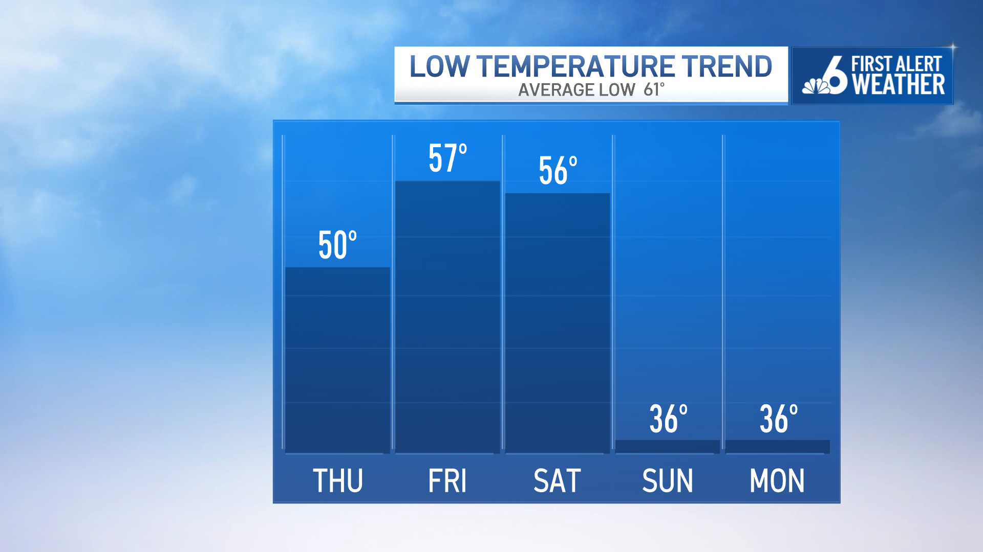
Today: A 20% chance of showers. Increasing clouds, with a high near 67 degrees. North wind around 10 mph.
Wednesday morning is cool with temperatures near 50 degrees. Feel-like conditions inland are back into the mid-40s. There isn’t as much wind on Wednesday morning, but we still have a light breeze to kick off the day.
Wednesday afternoon features sunshine that fills in with some clouds as a stray shower is possible. Not everyone will see rain, but we can’t rule out a passing shower. Highs reach back into the mid-60s. We’re reaching for a high temps near 67 degrees.
Expect another crisp night.
Thursday
Thursday: Sunny, with a high near 70 degrees. Northeast wind around 10 mph, with gusts as high as 20 mph.
Temps fall back near 50 degrees. Refreshing and cool air settles in through the end of the week. High temps will try to reach for 70 degrees by Thursday. It’ll be very similar into Friday, too.
Friday
Friday: A 20% chance of showers, mostly cloudy, with a high near 71 degrees. Northeast wind 6 to 8 mph.
Friday, a few passing showers are possible as an area of low pressure begins to develop in the gulf. This is going to be attached to the cold front that will bring arctic air down into South Florida by the second half of the weekend.
Saturday
Saturday: A 40% chance of showers, partly sunny, with a high near 68 degrees. Breezy, with a west wind 6 to 16 mph, with gusts as high as 28 mph.
Saturday, the front moves through and showers are expected ahead of the major temperature drop. Temps on Saturday afternoon warm into the mid-60s. Then, behind the cold front showers, temps fall into the 30s!
It’s going to be very windy with gusts up to 30 mph. This is going to give us a windchill factor.
Sunday
Sunday: Sunny, with a high near 55 degrees. Northwest wind around 15 mph, with gusts as high as 28 mph.
Feel-like conditions are already being highlighted to feel like the mid-20s by Sunday morning. The arctic air stays in place into the afternoon with highs only reaching into the mid-50s.
Sunday morning there could be a near record-low with a forecast of 36 degrees in Miami. This would tie the record-low for the date Feb. 1 in Miami previously set back in 1909.
Fort Lauderdale’s current record low for the date is 33 degrees, which might be just a little too far to hit.
Some history: With temps in the 30s, this will be the coldest air we’ve seen since December 2010. Miami last dropped to 36°F on December 14, 2010, with Fort Lauderdale reaching 34°F that same day. Later in the month, Fort Lauderdale fell to 36 degrees on Dec. 28, 2010. 
Monday
Monday: Sunny, with a high near 61 degrees.
It’ll be another cold morning on Monday before the arctic air starts to slowly retreat.
Now, Monday morning could also be in record territory for the date with a low forecast again of 36 degrees for both Miami and Fort Lauderdale. The current low record for Feb. 2 in Miami is 35 degrees set back in 1942. Fort Lauderdale’s current record for the date is 38 degrees set back 1979.

Is this the coldest South Florida’s ever been?
Temperatures in the 30s are extremely rare in South Florida.
Fort Lauderdale’s all-time record low is 28°F, set on January 20, 1977. Miami’s all-time record low is 27°F set in January 1940.
Current projections for early February are approaching those levels, underscoring how unusual this cold spell could be.