Summery stretch
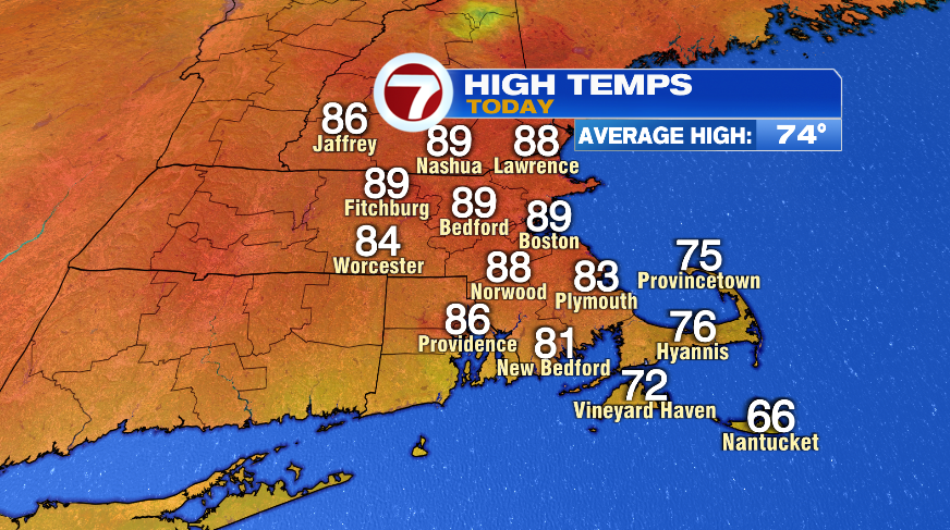
While the first two days this week were nice, we really turned up the dial to full on summer mode today. Not only were temperatures hotter, but the humidity came surging back in too. Highs today made it to the upper 80s! (this as of 3pm). The humidity also surged going from the 40s Monday, to the 50s Tuesday, and now to the 60s today. Dew points in the 60s are where the air gets pretty thick and it only goes up from here. By Thursday and especially Friday, we’ll be knocking on the door of, if not into the tropical air.

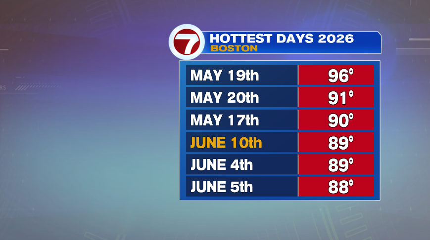
Boston’s high of 89° is good enough to find a spot on our “hottest days” list, which probably isn’t too surprising given that summer is really in just its early stages. Our average high as you see above, is still only in the mid 70s. But there’s plenty more heat and humidity to come. In fact, tomorrow will likely land itself somewhere on this list too.
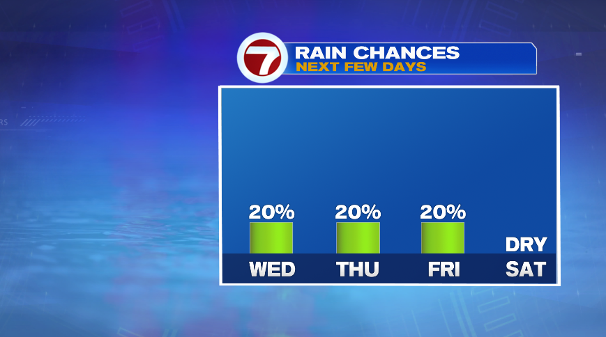
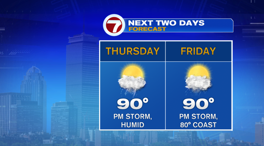
We have summer-like heat, we have summer-like humidity, and even a few summer-like passing thunderstorms. Each day for the rest of the week (this evening, Thursday and Friday) will feature these pop-up/passing storm chances, but the chance is low. We could actually use a few days with more widespread storms (non-severe of course) to help put some water in the backyards. I would suspect that nobody sees rain all three days moving forward. In fact, I think there will be several of us that don’t see a drop of rain in the next three days combined. And despite needing the rain, it does look like the small storm chance will be out of here on Saturday and FOR ONCE actually set up a really nice, summer-like weekend for Saturday and Sunday! Yay!
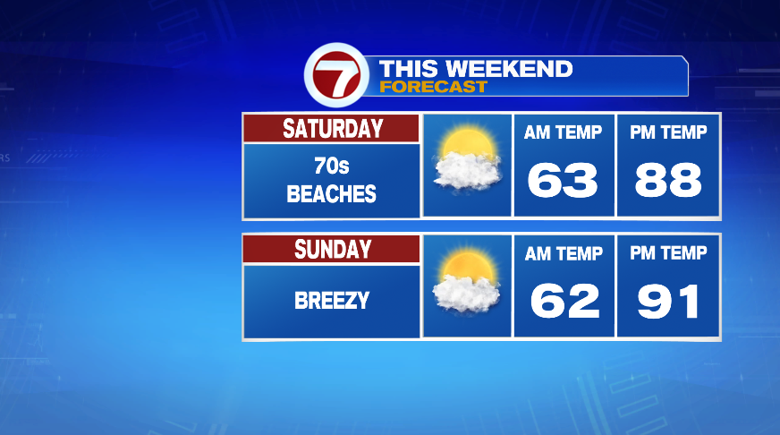
The heat will continue to build tomorrow with many towns hitting 90° tomorrow afternoon. With the humidity that continues to climb, feels like temperatures will likely find themselves in the low to mid 90s tomorrow afternoon. It will again feature that low chance of an afternoon/evening storm. Friday stays hot (inland) and incredibly humid. The difference Friday is the afternoon will develop a pretty potent onshore wind that will eventually drive the cooler air farther inland that the typical shallow sea breeze otherwise would. So while far inland spots have another hot and muggy day, the beaches will likely see temperatures only reach the 70s and most towns near the coast in the lower 80s.
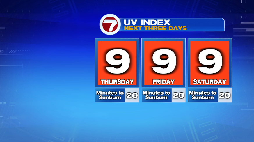
If you’re out on the beach or just doing anything outside tomorrow, don’t forget the sunscreen. The sun now is about as strong as it gets all year long. So we’re looking at less than 30 minutes to get a little bit of color in the afternoon sunshine. This will hold again for Friday, Saturday, and even Sunday.
And to completely bury the lede from the title, the weekend forecast looks OUTSTANDING! We’ll have mostly sunny to partly cloudy days both Saturday and Sunday. Both days have summer like temperatures, with a sea breeze keeping the beaches a little cooler on Saturday. Sunday will have a breeze that picks up and kick out the sea breeze for most of the beaches across eastern Massachusetts, though the Cape beaches will still be a bit cooler. Still, it’s a fantastic day to find a spot on the sand, or do just about anything outside!