San Diego weather: Scattered rain chances and dry conditions Sunday

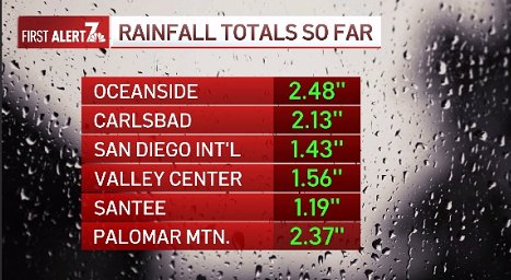
The storm yesterday certainly delivered, particularly along some of our coastal areas. Here’s a look at some of our more notable rainfall totals.
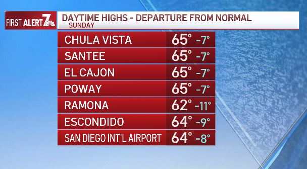
Remnants from Saturday’s storm will bring continued rain chances, but there will be longer periods of dry weather. Cooler, below-average temperatures will also continue, accompanied by breezy southwest winds over our mountains and deserts, ranging from 25-35mph.
A second storm system to our north will bring rain chances back into the forecast Monday and Tuesday. Currently, the timing of this system indicates rain chances will increase late Monday afternoon and continue through Tuesday morning and afternoon. This system isn’t expected to have as much moisture associated with it, so rainfall rates aren’t expected to match Saturday’s conditions. However, given that we aren’t expected to have a full day of dry weather between storms, it’s likely there could still be flooding on roads and intersections, and even over rivers, creeks, and streams.
These could chance, but here are the rainfall estimates Monday and Tuesday:
COAST: 0.70’’-1’’
VALLEYS: 0.70’’-1.5’’
MOUNTAINS: 1’’-1.5’’
DESERTS: Near 0.25’’
A third system could bring more rain chances to San Diego County Thursday and Friday, but next weekend looks dry and warmer.
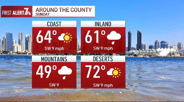
SUNDAY:
COAST: Low to mid-60s, scattered rain
VALLEY: Mid-50s to upper 60s, scattered rain
MTNS: Upper 4os to mid-50s, rain, windy
DESERT: Upper 60s to low 70s, rain chances, windy