San Diego weather: From a windstorm to Santa Ana winds this weekend

A storm to our north will be a wind producer, not a rain maker. Winds will be strongest over the mountains and deserts, but even the coast will be breezy this afternoon with gusts up to 30mph.
The storm is also bringing a lot of energy over the water, with higher swells today into tomorrow and a high risk for rip currents. High tide today is around noon, it’ll be around 1:15pm tomorrow. Steep seas are also expected in the open seas.
San Diego’s mountains and deserts will be under a Wind Advisory until 1pm. Wind gusts will range from 40-55mph, strong enough to bring down trees, powerlines, and to make difficult driving conditions for high profile vehicles. The winds will subside this afternoon but remaining gusty at times into tonight.
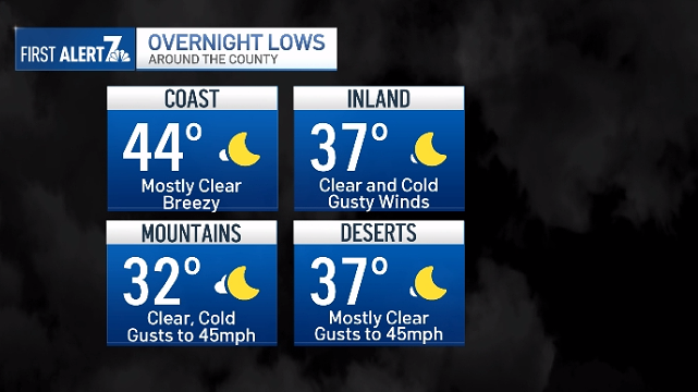
Our wind making storm will leave colder air as it retreats the area tonight. The sky will be mostly clear with many parts of the county in the 30s or low 40s.
Also, overnight the winds will begin to turn of the east with Santa Ana conditions set to impact areas west of the mountains Friday night into Saturday morning. The weather pattern will keep dry, easterly winds in place into next week with warmer temperatures. Inland valleys and deserts could see temperatures around 80 degrees next week.
WEDNESDAY
- Coast: chance AM light showers, then cloudy – 63
- Valles: chance AM light showers, then cloudy – 65
- Mountains: chance showers – 49
- Deserts: chance showers – 67